Saturday, September 7, 2013

A Wild Ride

September 7, 2013 - Saturday
You are not going to believe what we did today. We rented an ATV and headed out into the dunes. What an experience!! We were pretty much scared s...-less most of the time as we bounded up and down over hills of sand; you would swear you'd never make it. We were totally on our own, no guide. We had a ball! Lynn kept hollering to go here, don't go there, but Dan couldn't hear her through the helmet. Of course Dan got lost, but fortunately we took the GPS. Oh, then there was Lynn telling me where to go....and she was right!  Might still be out there without those "yells".


September 6, 2013 – Friday
It rained lightly off and on most of the night, so it was foggy and cool this morning. We set off going south down 101 toward Coos Bay. We jogged over toward Charleston on Cape Arago road. Charleston is a commercial fishing port on Coos Bay, so we stopped to watch as they were offloading some fish. Some of the boats were interesting, as the following picture shows.


It was clearing nicely as we arrived at Sunset Beach. This is supposed to be a decent tide pool area, but the tide was on the rise when we got there, so we may go back in a day or two. Low tide is pretty early in the morning again. The beach is pretty as you can see in this picture.


A short ways down the road was Cape Arago and the lighthouse. The lighthouse is offshore on an island, owned privately, so we couldn’t visit it. The viewpoint was a mile or more away. Cape Arago is very scenic with its combination of sandstone and basaltic rock.


Another half mile was Shore Acres State Park. This one gets a 10 for the most scenic state park. Contributing big is the Simpson Garden, named for the original owner. This dude made his fortune in lumbering, so he built a big house with a formal garden. A series of unfortunate events forced him to leave it and the State bought it and restored the gardens. The mansion burned down. The garden is beautiful with plants from all over the world. It was tough to figure out which pictures to upload, here are our choices.


The following is a shot of Simpson's Reef, a hangout for sea lions and seals. It looked like some of the beaches around here on Labor Day. You could hear them hooting a half mile away. Pretty funny!


Next we drove down 7 Devils Highway to Bullard State Park to see the Coquille River lighthouse. We had conflicting information about whether it would be open, it was not. This one looks like it is in need of some TLC. It is not operational and the Fresnel lens and light have been removed.


The light is located where the Coquille River empties into the ocean. Being at high tide, there were big breakers coming in. We watched as a boat attempted to enter the river. I would estimate it in the 30 foot range and had to make several attempts as the waves were breaking a good 3 feet high at the mouth. There were times where we thought he was going into the rocks along the jetty, but he did make it. We’re pretty sure the big wave action coupled with the high tide contributed to the nasty conditions.

We finished off the day in Coos Bay where we had dinner then walked the very nice waterfront boardwalk.

Thursday, September 5, 2013

Killer Plants and Lighthouses

September 4, 2013 – Wednesday
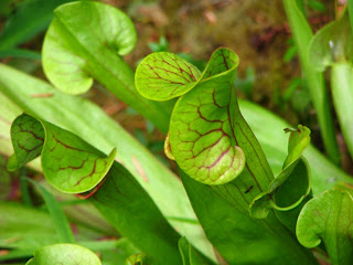
It was foggy and overcast when we got up today, but as we have learned, stick with your plans as it will probably clear later, which it did. We headed back up north with the first stop being the Darlingtonia State Natural Site. This is an area set aside to protect a carnivorous plant called the Darlingtonia Californica, a plant shaped like a cobra head that attracts insects, eventually trapping them and digesting them. It only grows in boggy locations in this area of Oregon and northern California. The trail was a boardwalk over the bog. No flies, mosquitoes, or other bugs were seen here. I wonder if we can grow them at home? A picture follows.


Next was the Heceta Head Lighthouse, a bit further north. This and the Umpqua River Lighthouse were built from the same plans and about the same time. My theory is since the original Umpqua LH slid into the river and a new light was needed quickly, they used the same plans from the Heceta LH which was completed in 1892. The only difference between the two lighthouses is the light pattern.

Other interesting facts, it has been under renovation for the last 2 years, it reopened in June 2013. Cost of renovation was over $2 million. The lighthouse was named after a Spanish surveyor, who likely never even saw this area, go figure! It is the most photographed lighthouse on the coast, so here are a couple of ours.


We made a quick stop in Florence to the library for WiFi for yesterday’s post, then did a little dockside exploring. Here are a couple of interesting fishing boat pictures that we found in the Old Town area of Florence.


For those of you familiar with the area, we decided to pass on the Sea Lion Caves. Although it seems to be a popular tourist stop, locals told us to skip it. Actually two on different occasions told us it is not that interesting and as we can imagine, it stinks, literally.

Anybody figure out how to tell the sex of a crab? Well as luck would have it, there was a guy fishing for crab, yep with hook and line, instead of a trap. He had a keeper in his cooler that he took out so I could get the following picture. The female belly has more of a checkerboard pattern. The long V pattern is the key to identifying a male.


We finished off the day poking around the sand dunes a little. We aren’t big sand dune fans, so you may not get much from us on that, but then again, maybe?

A comment about our current campground, it’s empty, quiet, and very dark at night. Finally after a month in Oregon we finally find some peace and quiet!

September 5, 2013 - Thursday
We woke to pouring rain, thunder and lightning. Power was off and on. So we hunkered down until it quit raining about 2PM. We then headed back to Umpqua Lighthouse to see the part of the museum we missed on Tuesday. Very interesting Coast Guard area history, and more about the area in there. The folks that run this place are volunteers, and they are very passionate about their lighthouse. They are responsible for keeping it clean and working, as well as run the tours, etc.

Last big attraction was a visit to Lakeside Library for their WiFi. Wanted to check it out as it is only a few miles from the campground. Internet works, but email doesn't. Weather is supposed to improve overnight, so we will resume our travels tomorrow. Hope you are enjoying the ride. Let us know if you want to see more (or less)of the type of stuff we are posting.

delarkin@comcast.net

Wednesday, September 4, 2013

Rocks to Dunes

September 2, 2013 – Monday
There wasn’t much on the agenda today. For starters we went on a search for WiFi to update the blog. Lynn had researched some locations and we finally found it outside the South Beach Library. It was however giving us fits getting our email, but did permit internet access, so last post was compliments of that connection. We finally got the email working by changing our port numbers in Outlook. The WiFi thing is something that needs to be investigated after this trip. We also need to investigate better blog vehicles. The Goggle Blog we use is not efficient in uploading text and pictures. Ideally, it would allow the updates prepared off-line then simply uploaded as a total file. Sounds like a good winter project!

We spent the afternoon walking the beach in Newport. At low tide we saw some starfish and sea anemones in the tide pools created along side the jetty. Seeing a couple sea gulls fighting over a rather large crab bring a couple of things to mind. First, why don’t we eat sea gulls? Geez, some are the size of big chickens, and they seem to eat well with the crab you see them with. And second, although we do not plan to go crabbing, we were looking at the rules. To keep them, they must be at least 5½ inches across the shell and be a male. Do any of you know how to determine the sex of a crab? No, this is not a dirty joke, although I can think of a few lines to put here….. There is a pattern on their belly you need to look for. If we can find one to photograph, we’ll send it along.

September 3, 2013 – Tuesday
Today is moving day. We are heading south to William W. Tugman State Park, about 75 miles down the coast. If you have your maps out, the park lies just a bit south of Reedsport at Eels Lake, a small lake with a 10 mph max speed. We wish we had the Porta-Bote. As we drove south, the landscape changed from big rocks to dunes. We think Michigan’s are higher, but these are scenic. Highway 101 was pretty twisty much of the way down here.


The weather is quite nice today, hopefully it is starting a trend. Since we had some time, we visited the Umpqua Lighthouse. Built in 1894, it replaced the original lighthouse that slid into the river in 1864. Its purpose is to mark the entrance to the Umpqua River with a unique alternating red/white pattern light. This is still an operating lighthouse, though you can go inside via a tour. It was fueled by kerosene and tended by a Keeper and 1st & 2nd Assistants. Today it is powered by a 1000 watt, 2.5 million candlepower electric bulb. The 1st order Fresnel lens makes it visible 20 miles.


We will be at Tugman for several days, there are several things to see and do in this area.

Monday, September 2, 2013

Up The Coast

September 1, 2013
Today we decided to head north up Hwy 101 toward Depoe Bay. This is of interest because of its Whale Center. Apparently about 200 whales hang around Depoe Bay all year, so there is pretty good odds of seeing one. We knew a bit about whales from our visit to San Diego, but we really didn’t know much about Baleen. Baleen is a whale’s teeth. They suck up sea water including mud and blow out through their Baleen, which catches the krill (a small shrimp) and is then eaten. Baleen is the same type of material as our fingernails and grows continuously; a picture follows.


Depoe Bay is “advertised” as the smallest commercial bay on Oregon’s coast. Only a few commercial fisheries are here. It’s mostly pleasure boats and charter fishing services. We then drove south to Cape Foulweather. It is very scenic, but the coolest thing we saw were a couple of whales. Actually, their water spouts, about 2 miles off shore. The area was very scenic. A couple of pixs follow.


The next stop was Devil’s Punchbowl. This area contains sandstone where the water has hollowed out tunnels and depressions that churn up the incoming waves. The water trapped in this area swirls, crashes, and spits. Although we were at high tide, the ocean was too calm to really make this thing work.


We stopped at Seal Rock SP as it was low tide. The tide was just not low enough to get out far enough and reach the areas we wanted to see. So far the best tide pool area has been Indian Beach in Ecola SP.

Weather-wise, it was a picture perfect day until sundown. It is now foggy with a misty rain. I seems as though you can only string together a day or two of nice weather at a time.

Down The Coast

August 31, 2013 – Saturday
Today we set the compass to “S” and drove down the coast for several planned stops. The first was Seal Rock and its beach. It was high tide, but the beach is very nice and with all the rocks should make a good tide pool without flies and a rocky beach to deal with. It warrants a return visit. A couple pictures follow.


Next stop was Waldport, mainly because of the Alsea Bridge. This is one of several bridges designed by Conde McCullough, Oregon’s state bridge engineer between 1919 and 1935. His design’s carry a Roman influence and are artistic as well as functional. His best known bridges are the five built along Highway 101 to span various waterways that required ferrying cars. Highway 101, the coastal highway, was built for military strategic use in the 1930-1940s, mainly as WPA projects, to move troops and equipment for protection of the coast before and during WWII. As usual, it got completed after WWII was over.

The Alsea Bay Bridge was rebuilt in the 1990s. They required that the new bridge carry McCullough’s design trademark. It was built along side the original utilizing concrete techniques not known in the 30s. The old one was then demolished. The following photo shows that new bridge.


Next stop was Yachats. This is a unique little town with really unusual houses. Their draw is a number of trails, many connected to the Oregon Coastal Trail. A couple of them were of interest to us. The first departs from Smelt Sands SP. This trail goes several miles up and down the coast along a rocky bluff above the ocean. It is a wide, smooth, and a pretty flat trail with bench and picnic tables scattered along the way. It goes right in front of beachfront homes and hotels, like close in front of. In Oregon, all the beaches are public including the land next to it. We’re not so sure it would be great having the public passing within 50 feet of our house.


Another trail was in the Gerdemann Botanical Garden, which had a surprising collection of plants you would expect in the tropics, but not here. We then walked the Amanda Trail that has a statue of Amanda, a blind Coos Indian girl forced to walk along a rocky trail as the Indians got herded to reservations. Following is a picture.


The last stop for the day was Cape Perpetua. We took the Captain Cook Trail that leads to tide pools and to Spouting Horn, a rock out cropping that shoots up a column of water when a wave crashes in. It was low tide, +2.8 ft, so we went out to have a look at the tide pools. There wasn’t much to see as the tide was not low enough. At this place you needed to be Spiderman to negotiate the big rocks you had to climb over to get to the water. This place, like Cobble Beach, is a write off for tide pooling. Spouting Rock wasn’t spouting due to low tide and calm conditions.


It is now very foggy, damp, and cold; so we are heading back to base camp.